Little Diamond Creek Battle, 1866
|
|
Little Diamond Creek Battle, 1866 |
||||
|---|---|---|---|---|
|
||||
|
The Utah Black Hawk War was at it's peak, when late at night on June 26, 1866, a band of Timpanogos Indians led by a Colorado Ute warrior named Chief Mountain came down Maple Canyon in Utah County and made a foray into the valley as far as Roundy's pasture about three miles south of Maple Canyon. They drove off 15 horses and thirty-eight head of cattle, resulting in the deaths of six Natives and two whites.
This became known as the Diamond Creek Battle which took place in the mountains of Little Diamond Fork in Spanish Fork Canyon, Utah.
Because there are conflicting historical accounts regarding the actual site, the people involved, and other questionable details of the Diamond Creek Battle, in 2008 historian Phillip B Gottfredson spent considerable time doing field research at the site where the battle took place to bring clarity to this important event. "My great-grandfather Peter Gottfredson gave an accurate description of this battle site in his book Indian Depredations in Utah. We were able to piece together what actually happened," said Phillip.
Phillip brought together some experts. They explored point-by-point every historical account available and came to some interesting conclusions.
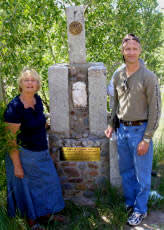
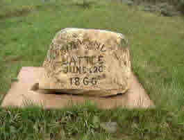
Curiosity over two monuments that reference this event, the one pictured top of this page is at the mouth of Little Diamond Creek erected by the Sons of the Utah Pioneers, and the next one is near the top of Little Diamond Fork. Phillip found that neither commemorate the event nor mark the actual site. After studying several historical accounts, we found discrepancies and decided to research the battle further and visit the site to determine the exact location.
Special recognition goes to Officer Shane Fredrickson of the Orem Police Swat Team for lending his expertise as an expert marksman. Earl David Ludvigson for his camera work, and my brother David Gottfredson's expertise as a surveyor.
The number of cattle that were stolen depends on who's account you are reading. One story goes that a band of Timpanogos stole cattle and horses, estimated to be between 20 and 50 in number. We were able to narrow that down to a more accurate figure. Peter Gottfredson's firsthand account notes there were 38 cattle and 15 horses. His would be the more detailed account because he said there were 16 saddles found after the battle. For the sake of argument, it is more important to visualize there being approximately 53 animals, both cattle and horses in all, perhaps more.
Estimating the number of animals is essential in helping us understand how amazing the feat was to move animals and men over a rugged mountain pass at night, named Maple Canyon, described as steep, narrow, and very rocky. I was not in good shape enough to climb to the summit, but some local horsemen I spoke with said it was too steep for them to cross over the summit on horseback, being rocky and very difficult at the top. I found that to be consoling to my ego, actually.
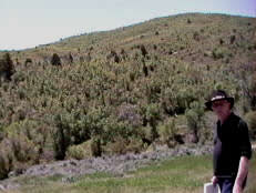
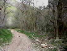 This photo is Maple Canyon Trail leading to the pass (east bound from Mapleton) which drops over the mountain into Little Diamond Fork. This is the easy part of the trail. The rest becomes very rugged and narrow. It took only 2 hours, in the darkness of night, for 53 animals and some 12 Native braves to travel 16 miles up this trail.
The story continues that about 4:am on June 26, 1866, warriors were led by a Colorado Ute named Mountain. He was a friend of Timpanogos Chief Antonga Black Hawk. Mountain, and his braves, had taken cattle and horses from a ranch located on the foothills of Maple Mountain, above Mapleton City, Utah, and drove them through the rugged, narrow canyon east over the summit into Little Diamond Creek. There they rested for a while in a "broad open meadow," thinking they may have outsmarted the ranchers and had a good lead on them.
Meanwhile, back at the ranch, around 8 am, Colonel Creer of the Nauvoo Militia (Mormon army) brought together some men to go after Mountain and his warriors. Alma Spafford, H.O. Crandall, T.L. Mendenhall, J.A. Grosbeck, John Edmundson, Loren Dibble, D.C. Johnson, an old soldier named Gillispe, Wily Thomas, and Al Dimmick were in Colonel Creer's militia.
About 9:am a second squad of men from Springville followed behind Creer's men, and among them were three anxious boys determined to ride ahead of the others in pursuit of the Indians.
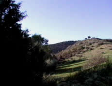
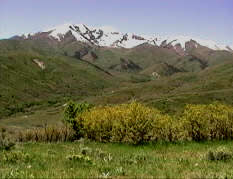 Where the snow ends on the right in this photo is the top of Little Diamond Creek as you descend from Maple Canyon. The location, where this photo was taken, is where the marker in the above photo (The rock) is located as being the location of the battle. The creek runs through a narrow canyon of this area shown. The marker, not visible here, sits in the area of the lower left hand corner of the photo, but is about one mile above where the actual battle site is located.
 Standing directly in front of the marker (the rock) claiming to be the site where the battle took place, this area could not have been the "broad open meadow area" described in the accounts, nor would it accommodate 53 tired and thursty animals and 12 or so men. And there are no "knolls" described in the accounts, as I will explain.
We established that Creer and his men in hot pursuit of the Indians, rode as fast as was possible up the steep Maple canyon, over the summit, and dropped down into Little Diamond creek on the east side of Maple Mountain. The three boys trailing behind described as "young mad-caps" who were anxious to find the Indians road ahead came to a knoll where they spotted some of Creer's men hunkered down in a clump of trees firing at the Timpanogos who were undercover south of the area. They waited for the rest to catch up there, and when they came down the canyon, the three men to arrive earlier shouted to Creer's posse of men to get their attention and pointed to the Indians who were just around the bend and below the knoll.
 In this photo I am on top of a knoll exactly one mile down the canyon east of the rock monument, (Location of the monument is over the far ridge above my right hand), this is the knoll from which the three men saw Creer and alerted the posse that they had spotted the Indians just around the opposite side of the knoll to the left from where I am sitting. From here they could see the battle site on my left side and an advancing posse from my right.
The story continues that Creer and some of his men advanced to the top of the knoll, where the three boys were, and hunkered down when Timpanogos warriors suddenly attacked them from behind. Two of the attackers were killed while Creer and his men began firing on the Indians camped down below. It is said, "the battle went on for a couple of hours when warrior Mountain road up on top of the opposite knoll in the far distance being 800 yards away. Mountain, who knew Dimmick, began harassing Dimmick calling him a 'coward and a squaw', when Dimmick stood up and fired at Mountain, only to be gunned down as a result." Dimmick was mortally wounded and taken to the "shade of a tree" on the north side of the knoll. That tree still stands. The story said that "Creer selected five long rifles and fired at Mountain five times at a distance of "800 yards," and the fifth shot appeared to hit Mountain, causing him to slump over his horse. Mountain disappeared over the backside of the knoll."
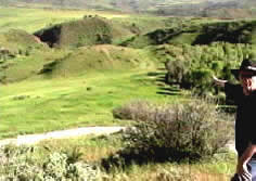 This is the actual site where the battle took place. All of the elements in the stories are here. From the knoll, upon which I am standing, I am pointing to the large flat meadow area where warrior Mountain, the cattle, and his men were. I am pointing directly at the thicket where Mountain and his men made their escape and one white man was killed. Creer and his men where here on the knoll where I am standing, and where Dimick was shot. Looking at the knoll in the distance, just at the end the row of trees is where Mountain was allegedly wounded by Creer. A distance of 250 yards, not the "800 yards" as told in one account. We are looking east in this photo, and the second far distant knoll is where the Diamond Fork River and Little Diamond Creek converge on the opposite side.
 In this photo we are in the cover of the trees in the thicket below looking back up at the knoll where Creer and his men were firing at the Timpanogos. Distance: 250 yards. Then just to the left of the round tree on the very top of the knoll is where I was standing in the previous picture. To the right of the round tree and down the side of the knoll is where Dimmick lay dying under a Juniper tree.
When warrior Mountain was allegedly wounded, the Indians were seen escaping to the south side of the knoll and then headed north up the canyon toward Timpanogos Mountain and on through Strawberry to the reservation. The three "young mad-caps" road after them into the thicket, and more gunfire was heard. Two retreated, and then silence. When Creer and the others arrived at the gruesome scene, a total of four Timpanogos lay dead in the thicket. Edmonson, however, was nowhere to be found. It wasn't until the following day when a search party from Springville discovered his body about three-quarters of a mile north of the battle. He had been stripped of his shirt, shot twice through the heart at point-blank, scalped, and his missing right hand severed from his wrist.
The Timpanogos survivors having made their escape, Creer and his men rounded up what remained of their cattle and horses. The Timpanogos had left behind several camping items. There was a new lariat rope, knives, blankets, 16 saddles, and axes. Much of the items were gathered up, and they began to discuss which route they should take to get back home to Mapleton. Fearful of being attacked at night, it was argued that taking the easier way down Spanish Fork Canyon would be too dangerous, not knowing if Mountain and his warriors were still in the area. After much discussion, they decided to take the same trail back through Maple canyon. While Dimmick lay dying beneath the tree, he begged the men to shoot him. He was in so much pain. Around midnight, they built a liter to carry him on and began their trip over the summit and back to Mapleton, but near the top of the Mountain, Dimmick died.
The posse arrived back in Springville about 3:am the next day, and the town came out to greet them. They were heralded as heroes. It was recorded in Springville history that Antonga Black Hawk was shot during the battle. They bragged that Creer had shot him with a rifle at a distance of 800 yards. Of course, none of this was true. It was Mountain, a friend of Chief Black Hawk. Black Hawk wasn't even there. He had been shot in the stomach at Gravelly Ford near Scipio just 16 days before, and I couldn't imagine he was feeling well enough to engage in this battle, and he was mourning the murder of his father Sanpitch that had also occurred just days before.
Note: Black Hawk and Mountain were not blood relatives. Mountain was a Ute from Colorado, while Black Hawk was Snake-shoshonee Timpanogos. Black Hawk reffered to Mountain as his brother which is customary for Native people to say to someone they have deep respect for. But the Timpanogos and Ute are different tribes in origin, language, and customs. See The Timpanogos Nation Is Snake-Shoshone
Let's return to the site again and survey the distances, we discover that 800 yards is a very long distance to hit a target, even for an expert marksman. David, our surveyor, measured 800 yards with his surveying instrument, and a man at 800 yards away would appear to be about a half-inch tall in a rifle's sight. With the naked eye, half that. According to our expert marksman, today's high-powered rifles with high-powered scopes can hit a target at that distance, but it would be a difficult, according to Shane our expert. We are talking over a hundred and thirty years ago, and while long rifles were accurate for around 300 yards, some say more, hitting a man on a horse at 800 yards would be hell of a a lucky shot.
We're confident that we have found the exact site where the battle occurred. All of the elements essential to the story of the Diamond Battle work out perfectly in this location and coincide with written accounts. The two knolls, the wide-open meadow area, the stream to water 53 animals, the escape route to the south, the thicket where Edmundson and four Timpanogos died, and the tree where Dimmick lay mortally wounded. As described by firsthand accounts, all of the elements come together at this location. The second monument marking the battle location is located one mile east of the site, or where the road begins there westerly to Little Diamond. It also should be noted that the cottonwood trees in the thicket area are well over a hundred years old, and we had no problem agreeing that they might have been there at the time. And where Dimmick lay dying under an old Juniper tree, it just seemed more than coincidence that there is tree in the same place as depicted in the stories.
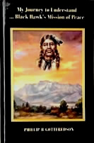
Source material: My Journey to Understand Black Hawk's Mission of Peace by Phillip B Gottfredson; Indian Depredations in Utah by Peter Gottfredson; John Alton Peterson Utah's Black Hawk War
Family photos courtesy of Franklin Nielsen.
Open Letter:
June 25, 2008
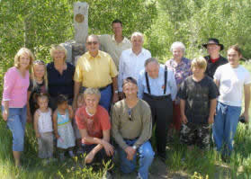
Today I had the honor of meeting the descendents of Albert Dimmick at the site of the above event. I had been invited by LaMar Adams who is the President of the Maple Mountain chapter of the Sons of the Utah Pioneers. Linda Dimmick asked if I would speak and tell the story of the event. And following the rededication of the monument depicted in the photo at the top of this page, I gave the family a tour of the battle site.
Indeed it was a great experience meeting Albert Dimmick's family and sharing their story. Always when meeting descendents of those who's ancestors were involved in the Black Hawk War is both emotional, and brings to mind that these stories are not just folklore, that the legacy of these events continue to inform our lives to this day in ways we can't fully comprehend and appreciate. Albert Dimmick died with honor, courageously defending the lives of his friends that day.
My gratitude goes out to the Dimmick family for spending the day with me. And may we always keep the memories of our ancestors alive for generations to come.
Thank you for your kindness and for giving me a copy of your families record of the event.
With kindness,
Phillip B Gottfredson
GPS Coordinates to Battle site: 40*04'11.18" N 111*26'10.74" W
See: Timeline
|